So many well-meaning followers have contacted me about the Alaska wildfires. Thank you so much for being concerned!
The areas that we are traveling in right now are not affected. But that's not to say on our route back home, that we will not run into some difficulties. We will be watching the current Wildfire Maps and regularly checking with 511 to see about road conditions.
The remnants of fires from the past years are very obvious. Here are photos while we are driving along the Seward Highway. We can see the remnants of the Swan Lake Fire from a few years ago, and the destruction of all of the trees on both sides of the road for many, many miles. It destroyed over 170,000 acres!!!
We can see the renewed growth now of green foliage on the ground. But it will take many many years for the trees to replace themselves and for this to be a beautiful lush forest again.
As we drove along towards the towns of Sterling, Soldotna and Kenai, the rains kept on and the skies remained dreary and clouded. It was not going to be a pretty day for scenery, that's for sure.
We did a stock up shopping at the Walmart in Kenai and picked up a few things here and there at the Three Bears and a hardware store. Seeing as we were in town, it was time to catch up on all those extra little things we needed to do. Then we started to look for a campsite nearby.
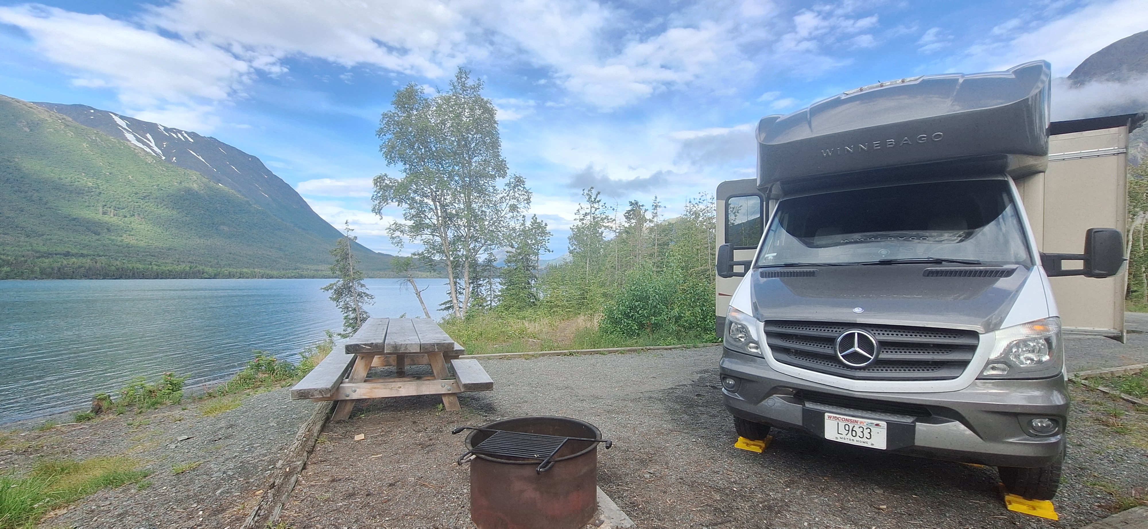
Just north of the city of Kenai, we saw a state park up on the Cook Inlet. It was called Captain Cook State Park! We drove on up there about 20 miles out of town and found a nice campsite. It was pretty easy to find campsites with the lousy weather, nobody felt like camping? There were a couple people in tents on the other side of the loop, and one other pickup truck camper nearby. That was about it.
We got all settled into our campsite and started putting away the laundry that we had done earlier in the morning. It was so nice to replenish our stash of towels and washcloths with freshly washed ones. Not to mention refilling our drawers of underwear and socks! Lol
Nick helped us put clean sheets on the bed. He is quite a helper, can't you tell?
After we got settled in, we made a nice meal in the pressure cooker of roast beef and carrots and taters. Step by step it's in the video down below at the end of this blog.
After doing dishes, we decided to take a nice little walk around the campground loop. Of course we always carry our bear spray, and our canned air horn. We set out on our walk and we were admiring all the beautiful wildflowers that are abundant right now. I don't even know what these little ones are called. Does anyone know?
The wild roses are in bloom everywhere. Their perfume is so strong, and it smells like a beautiful florist shop as soon as we step out of the motorhome.
These little bluebells are so delicate and wave in the wind and move around on the slightest breeze.
So here we are, wandering along, admiring the flowers. Somewhere down in the woods right above the tip of my finger, we didn't know, but there was a big huge bull moose! We were just wandering along on the campground road, only two sites away from our motorhome.
When suddenly CRASH CRASH CRASH he came loping through the woods right across in front of us and leaped up into the woods on the other side of the campground loop! Not sure why he was on the run? We could hear him crashing through the center of the loop over towards the people with the tents. Our hearts were pounding and we grabbed the dog and rushed back to the motorhome as quick as we could go. We could hear shouts and hollers as the moose crashed through the campsites with the tents and their dogs barking and everything was absolutely crazy for about 10 seconds over there.
Then it was silent. We were safely inside of the motorhome and evidently the moose kept on going and they were safe over there too.
Here is my heart rate on my Fitbit when we saw the moose! Lol
That was enough.
We stayed inside for the rest of the night... Steve took out Nick for one last potty break, and stayed right in our own campsite.
The campsites were located up on a hilly area quite a ways from the water. You really couldn't see the Cook Inlet from anywhere in the camping area.
So after we got packed up the next morning, we drove on down to the picnic area to observe the waters in the inlet. It's kind of like a big shallow bay that leads up past Anchorage and up into the Turnagain Arm.
The tide was out so we could see a broad expanse of the exposed floor after the tide had crawled out.
I told Steve that it was like seeing the terrain that only the fish see. Like the "secret world" under the sea.
We didn't want to walk down there, it gets kind of mushy and gooey. There are spots that it can actually suck your boots down in or you can get stuck. So it's best to stay up on the sturdy shoreline and don't go wandering in places where you could get into a dangerous situation.
It was kind of rainy and dreary, we decided to drive down further on the Kenai Peninsula along the shoreline. We were looking for some sunshine and a better place to hang out. We drove all the way down to the Kasilof Special Use Area where there's a beach that is known for free camping. It's really just a parking lot. But we found a nice spot, everyone was spaced out every other parking spot so it made for a comfortable place to camp for the night. Or so we thought???
See this on the back of the motorhome next to us? This is a huge dipping net for Salmon. When the salmon season starts (unknown to us it was the very next morning!) Alaskan residents are allowed to take these huge nets and catch salmon as they swim upstream to spawn. It's a huge event and every resident is allowed to get 25 salmon each, and 10 more per person in their household.
We didn't know about the opening of the season the next morning, we just knew that there were only about 20 campers in the lot, and we were quite comfortable. We had a beautiful view out our side window. We settled in for the day and we were happy to have sunshine again.
We even took a nap with the soft salty sea breeze drifting in through the windows. It was very comfortable and we were enjoying ourselves.
We took a walk around the little Harbor and beach area, and enjoyed the sights and the sounds of being "sea side" on the Cook Inlet. These are some old unused huge floating buoys for marking channels through the inlet, or mooring up to with larger boats that can't make it to the shore.
We saw plenty of eagles flying around, as they are very prolific in the area along the water's edge. They know the salmon are coming too...
I captured a few here and there with my camera, trying to follow them with the video camera is pretty hard. But it was enjoyable and I got some better pictures the next day at another spot that I will post in the next blog.
Of course there are seagulls all over the place too. They are quite the scavengers. They are pretty brave, they came right up to the camper looking to see if we had anything good for them. They are used to getting fed.
We looked across the inlet over towards the row of volcanoes along the other shore. We saw some strange cloud formations coming across the water. At first I was worried it was volcanic steam and ash!
But no, it was just some weird mist rolling in across the water. It must have had something to do with the change in temperatures. It was like a low rolling cloud with clear sky above. A very very strange phenomenon. We could feel the dampness coming in on the air all of a sudden hitting us like a brick wall.
Instantly, the warmth of the sunshine was gone and we could feel the salty air and damp breezes coming across from the west. This whole embankment of a foggy cloud rolled right along the surface of the water. We couldn't even see the rows of mountains and volcanoes on the other shore anymore. Everything was covered by this mist.
Then behind that rolled in some heavy heavy dark clouds. I thought we were due for a big storm. It looked really scary and threatening across the water.
Within an hour, it all blew away and we had blue sky again! We didn't even get any drops of rain. It's like it all absorbed up into the drier air above us and was gone???
Now the skyline across the way was all big puffy white clouds again. That was such a strange event.
By evening, after supper time, we noticed more vehicles coming into the lot. Quite a few drove right out to the beach and positioned themselves in optimum spots for the upcoming salmon run the next morning. Others were positioning themselves in the parking lot.
Before we knew it, all of the single spaces separating each motorhome we're now getting filled with other people's RVs. One couple was trying so hard to back their big motorhome in between us and the next person. They were literally within inches of our side view mirrors. They jiggled and juggled back and forth five or six times to finally get in. Once they were parked in right tight against us, their door could not even open because our door was directly across from them! They had to start up and move their motorhome back about 3 ft to stagger our doors. This was way too close!
On the other side of us, the people in the trailer next to us parked their extra vehicle right up tight against our motorhome. As they got out of their vehicle doors, they could not even open them all of the way. They were within inches of our rig and had to literally rub their bodies and their jackets against our motorhome to get around and out of their vehicle. We didn't want our paint scratched or get dings from opening and shutting truck doors!
It was time to move on...
We would have loved to stay and watch the fishing the next morning but it was beginning to turn into a carnival-like atmosphere.
People were shouting and hollering, unloading all of their gear (and beer) and people were full of excitement for the upcoming event. This is an annual thing, and the locals anticipate their ritual to fill their freezers. The music and the drinking and the fires on the beach were starting. This was not going to be a fun place for us to be...
It was time for us to pack up and get moving.
I didn't even take pics, we just started up our engine and pulled out as fast as we could.
Some lucky person was going to get a prime spot where when we vacated our position, right at the end of the parking lot near the beach.
I did find a video clip of the next day, of the people enjoying themselves exactly right out the back side of where we were parked. Here is the link to it below:
My oh my, what a circus!!!
We drove only a few miles further out of the special use area and found a nice quiet campground called Johnson Lake Rec area. It was peaceful and quiet, with only a few campers. We settled in for the night and got a good night's sleep.
Here is the YouTube video that goes along with today's blog:
I ended the last blog with our impromptu leaving Granite Creek and heading to the roadside viewpoint at the Canyon Creek Rest Area on the Sterling Highway.
We were glad we vacated that site, due to the increasing water levels. It's best not to take chances. What a way to wreck a vacation by being flooded out?
We headed on further west on the highway. Our goal was to find another quiet camping spot for a couple days.
It seems like that's really our main goal of this entire trip. Finding nice quiet beautiful places in nature. Places we would not see back at home. Places we can relax and look out and enjoy and explore. We're not doing the tourist things. We're not doing the crowds. We're not doing the restaurants or the main attraction sights to see.
We looked up on the map and saw there was another National Forest Campground just up the way. It was called Quartz Creek, and located on the Kenai Lake. We look for the National Forest campgrounds because our Federal America the Beautiful Senior Access Pass gains us half price camping fees. This one is part of the Chugach National Forest.
We pulled in and took a right hand turn. Out of the entire loop there were two empty sites that were not reserved. Sites number 39 and 44. We grabbed 39 and we have a feeling it was the best site in the entire park! (The host later confirmed that was so). It was now considered first come first served for the next five nights. It was not reservable by anyone else unless we gave it up after 5 nights. We decided to try for three and then watch the weather and decide if we should stay another two.
We quickly filled out our envelope for 3 nights, for the bargain price of $11.50 a night. And this is what we got:
Yep, we are parked right next to this wonderful aquamarine/azure/cobalt blue glacial lake. The colors are like that from the silt and the minerals of the melting glaciers feeding into the lake.
The puffy clouds going overhead played shadows and bright sections over the mountainside across from us. Look at the rich gorgeous greens, in contrast to the deep hunter greens when there are clouds covering the sunshine.
The water is reflecting back greens and blues and even a pinkish purple tinge. I look outside in any direction and the colors are different on the surface of the lake in each direction that I look.
It's like an artist's palette of different hues and colors. It kind of reminds me when I blend green, blue, and purple dye on wool fleece and let it spread and blend where it intersects with the next color. I think these are my new "favorite colors"?
We were standing down along the shore of the lake, we noticed that there weren't any mosquitoes at all. That seemed really strange! It was absolutely gorgeous and the day was climbing up into the mid '70s.
Steve took out our reclining lawn chairs and we settled down to enjoy the afternoon, gazing out across the water.
He had along a pair of binoculars to examine things over on the other shore. Nicholas wasn't sure what he was looking at. But he was paying close attention to see where Steve was going or if it involved him going along on a "walk".
After a while, I went inside to get some supper going. Steve had asked for one of his beers and I handed it out through the slider on the screen door. A moment or two later, I looked out and thought "oh my, this looks almost like a beer commercial!!". So I snapped a shot and added a caption:
After dinner, we took a walk around the rest of the campground. The loop to the left was pretty buggy and we were slapping mosquitoes the whole way. It was amazing the loop to the right closer to the lake had less mosquitoes?
We wandered along and I took a few photos as we went. I am just loving this purple lupine.
It's in full bloom right now. I love the cascading colors as it spreads up the stem from the leaves below.
Every shade of purple and violet that you can think of?
We looked across the lake in the evening and saw a lone kayaker paddling his way across. It makes me miss our canoe. But we sure didn't want to haul one all of the way to Alaska. Lol. Maybe we can rent one somewhere?
The next morning, we woke up again to these marvelous hues and colors spread across the lake. The water was smooth like glass and just reflected everything from the hills above. This is what it looked like when I pulled up the shade on the bedroom window.
The pinkish purples and the blues and the greens are just combined into a wonderful tapestry across the surface of the water.
We glanced at the weather forecast that afternoon about back home in Wisconsin. The Midwest, along with many other parts of the country, are really suffering from an awful heat wave, combined with high humidity to make an even more intolerable heat index. Back home it was over a hundred! Where we are in Alaska, it was very comfortable 58 because it had clouded over a little bit.
When the weather gets that hot in Wisconsin, it's very common for the concrete sections of the highway to explode! It has to do with expansion and contraction in the rapid heating of the cold concrete. The North and Southbound lanes right by the exit to Oconto both blew up during that afternoon heat. I know there was some video clip making the rounds on YouTube and the news of some other road blowing up somewhere else like it was a really strange phenomenon. But it's pretty common up in our area of Wisconsin.
This pic was on our local Oconto Facebook Group.
We spent a delightful evening watching this pair with their three little adorable babies. They are called the common merganser bird, and we really enjoyed watching the little ones follow around the parents. There's some video footage of them on the YouTube link down below at the end of this blog.
They entertained us by swimming back and forth and back and forth right in front of our lawn chairs. I had a hard time holding the camera to follow him. So I learned to just hold the camera in one spot and let him swim back and forth in front of it.
She was resting for a while, with her head twisted up over her back, and then she came over and swam back and forth too. She almost looked fluffy and fuzzy up close.
Look at the detail I could bring in on this guy! He kept swimming straight towards us like he wanted to check us out, to see if either of us were going to maybe give him something to eat?
I can think of nothing more delightful than sitting back in our chairs, and watching wildlife play out right in front of us. Nick was relaxed at our feet and not even concerned about the birds swimming back and forth. It was so totally peaceful.
Again, you will have to look at the video on the link below to see how these silly birds were entertaining us two old farts.
By our third night, things had clouded over and we could hear some rain on the rooftop. It was very gentle and soothing and we fell asleep to the sounds of the rain. In the morning, sadly, we pulled up the window shade and this is what we saw: clouds, fog, and more rain.
That made our decision not to renew our site for the next two days. The weather report said rain, rain, rain.
We loaded up and left our site to the next lucky occupant. The host even stopped by and inquired whether or not we were leaving that day, because he was sure somebody else would come and snap it up as soon as we vacated it. It would still remain a "first come - first serve" site until the next reservation started on the third day from now.
We stopped over to the dump station near the entrance to the park. It was unusual, but they required a separate payment to utilize the freshwater and dump station, even if you were already camping in the park. It was not included in the camping fee. Oh well, the camping fee was so low at $9.50 a night we didn't mind. An additional $10 wouldn't hurt, and the convenience sure was nice to have it available right at the exit to the park.
While someone else was ahead of us at the dump station, Steve was using the potable water to fill our freshwater holding tank. We always use a filter for anything that goes into our tank, even if it's municipal water like this.
Then inside, we use a Life Straw pitcher for anything we drink, cook with, or make coffee with. Also we use the Life Straw pitcher for Nicholas's water bowl.
This thing removes 99.99% of Bacteria, Parasites, Microplastics, Lead, Mercury, PFAS and a Variety of Chemicals and all the other crap that's in the water. The best part is the picture is glass and does not give you a "plastic taste" and is BPA free. We change the small filters every 2 months, and the large one every 6 months. We like this so much, we even use it at home. And we are not spending tons of excess money buying bottled water, nor cluttering up the landfills with our water bottles. (Non-sponsored, just really love this product!)
After we were done with our dump station procedure, we headed on up the road 3 miles on the Sterling Highway. We were going to Wildman's!
It's an all-in-one store with a deli, grocery store, coffee shop, gift shop, propane fill, liquor store, plus a mini laundromat and showers!
The only thing they don't sell is gas or diesel!
As I came up the steps, a couple free-range chickens came out to check me out. Boy oh boy, what is this with birds this week?
We tossed in our three loads into the washing machines, picked up a few things that we needed in the store, had our propane tank filled, and browsed through the giftware.
What a cute little laundry area? There were three working washing machines and one large one that was being repaired that was out of order. There were four dryers and each one was $2.50 for wash or dry. I hate laundromats, but this was cute and tiny and we got everything done in no time flat. $15 later and we had all clean clothes and both sets of sheets to put away.
Now it was time to head on down the road, and see where it was going to take us.
On to the next adventure!
Here is the YouTube video that goes along with today's blog post:

.JPG)
.JPG)
.JPG)
%20-%20frame%20at%200m30s.jpg)

%20-%20frame%20at%200m5s.jpg)
%20-%20frame%20at%201m31s.jpg)
%20-%20frame%20at%201m11s.jpg)
%20-%20frame%20at%200m1s.jpg)
%20-%20frame%20at%200m9s.jpg)
.JPG)
.JPG)
.JPG)
.jpg)
.jpg)
.jpg)
.JPG)
.JPG)
.JPG)
.JPG)
.JPG)
.JPG)
.JPG)
.JPG)
.JPG)
.jpg)
.jpg)


.JPG)

.JPG)
.JPG)
.JPG)
.JPG)


%20-%20frame%20at%200m1s.jpg)
%20-%20frame%20at%200m4s.jpg)

%20-%20frame%20at%201m22s.jpg)
%20-%20frame%20at%200m13s.jpg)
.jpg)
%20-%20frame%20at%200m0s.jpg)
%20-%20frame%20at%200m10s.jpg)
%20-%20frame%20at%200m36s.jpg)