We've been driving over the rugged roads of Alaska for the last 30 plus days now. Some of them in Canada were also challenging. But today was going to be one of the MOST challenging...

This is the famous road to McCarthy. It is 60 miles of very rugged terrain, most of it on an abandoned railroad track that was used for the copper mines 100 years ago. The signs warn you that this is not a normal road. Tow trucks will not come down this road to help you. Rental agencies will not allow their SUVs, Jeeps or RVs to go on this road. You are basically on your own if you head down it. And we were willing to do it...

It is 60 miles long. Once you get to the town of McCarthy you can't even drive into town. The road ends in a parking lot next to a river. You have to access the town by a footbridge. It's a unique little town that we had seen long ago on the Discovery Channel TV reality series called "Edge of Alaska". It's how the few town residents who stay there year-round deal with tourism and whether or not the town should expand, or stay as it is. It was quite a struggle for them to all agree on anything. Of course some of it is dramatized for the TV show. But we've always wanted to visit there.
Here's the link to the TV show:

The journey begins just off Alaska Route 10 in the small town of Chitina. There is one very small store and one gas station before you embark on this journey. It's best to be fueled up and buy enough supplies to maintain you during your stay. The town of McCarthy has very few items for sale, and no gasoline or diesel fuel.
We begin by driving between two very large chiseled out high embankments of rock. This is where the train went through, and this is where we will go through too.


I'm sure the river was wide enough at that time to create such high banks that are now all erosion and collapsing down into the riverbed. I think we read somewhere that this was actually a lake while the river was blocked off. Then eons ago it opened back up again by glacial movements and drained out.

We saw some folks fishing on the bank. With the ever-changing river flowage, this can be dangerous at times. You never know when it's going to cave in underneath you from erosion. But some people will do anything for a fish?

Spring is awakening throughout the woods. We stopped at the side the road for a little break and saw a huge clumps of dandelions. They grow everything bigger up here.


There was another area that we had to cross another river. This railroad trestle was in too much disrepair to be used for vehicle traffic. So we had to wind our way down the embankment, cross the river on a new small bridge, and wind our way back up. But we could see the old trestle overhead. Yes, that is not travel-able at all.


Here's the YouTube video that goes along with today's travels. Enjoy!

We worked our way through the wilderness and kept our eyes open for any type of wildlife. The most we saw were these mallard ducks in a marshy area. We are keeping our eyes peeled for the ever elusive moose. So far, no success.


Sunlight starts about 4:00 a.m. in the morning, and the sun does not set until 10:30 to 11:00 p.m. at night. It is still dusk with partially lit skies, well after midnight. It really doesn't seem to get dark at all right now in early June. Their growing season is short, but they grow huge vegetables because of the amount of daylight that they have per every 24 hours.
We wandered along the very rugged road. This is a type of road with no guardrails. You are driving at your own risk, and you need to be careful of where you are driving. Most of it is one lane. If there's an oncoming car, you hope that it's wide enough there that you can both sneak past each other. Either that or somebody has to back up a little, until it widens enough to get by. We only saw two vehicles coming towards us and both times we were able to maneuver around each other.
The scenery was breathtaking as we moved along through the countryside. I was snapping photos left and right, and kept a video going on the camera.

Our speed was between 20 and 30 mph. We estimated it would take us three to four hours to get through this 60 mile stretch of rugged road. But we also had to slow way down for obstacles. Almost to a crawling pace.
There were huge potholes and deep ruts from erosion from heavy rains. There were also natural springs bubbling up right in the middle of the road creating wet muddy spots. Most of the road was pretty level, seeing as it was a railroad bed. The grades were gradual as long as we were following the ancient abandoned railroad. We were warned of railroad spikes poking up here and there, but we did not encounter any, thank goodness.
At one point, we needed to follow the railroad path across this amazingly huge bridge over the Kuskulana River. It is 525 ft long and 238 ft in the air. It is a one lane bridge. The original railroad steel bridge span is used, and had been modernized with timbers for vehicles to traverse it now.
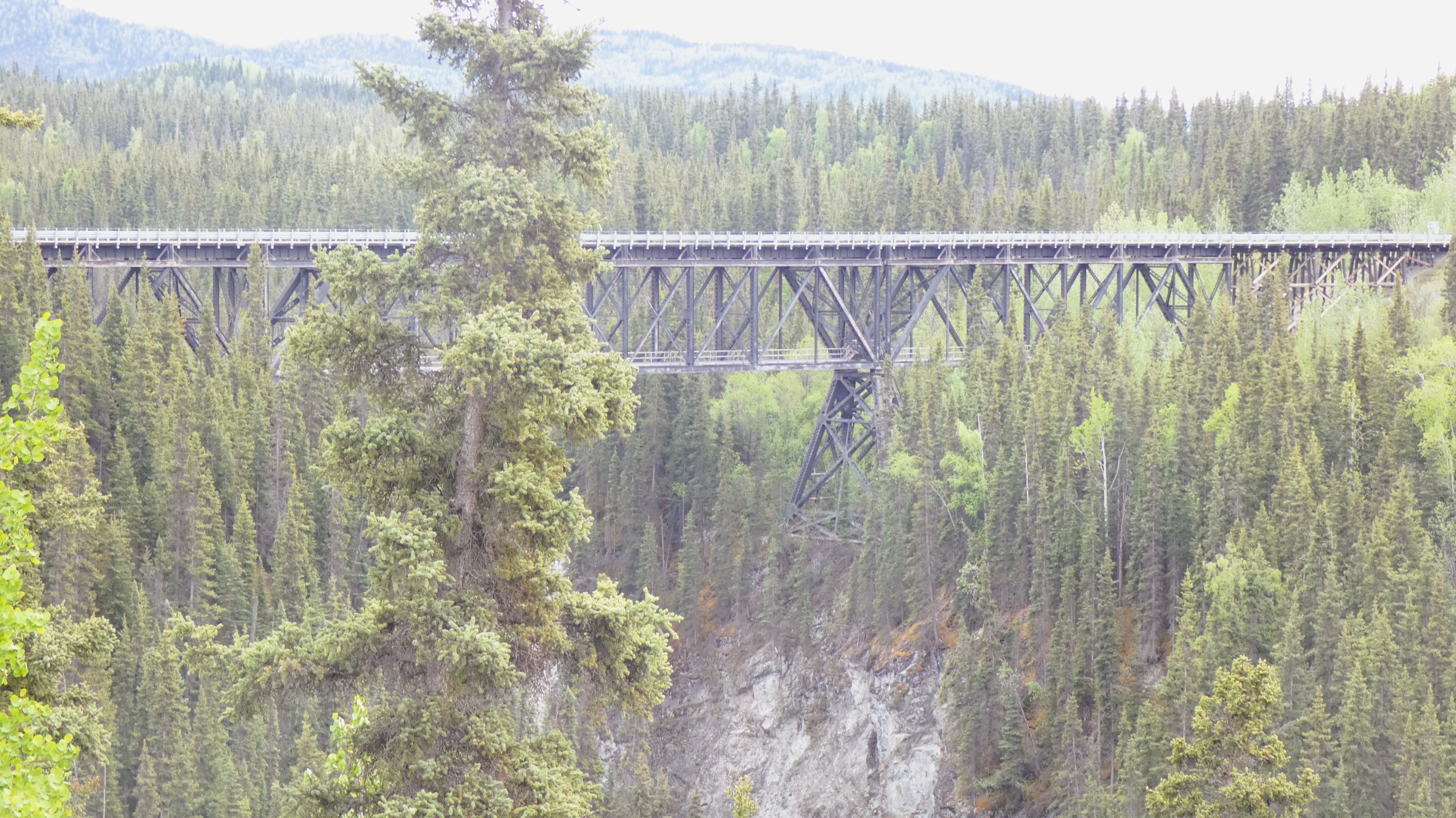
We held our breath, and we did it!
I have a hard time with heights.

Here is the river way, way, way down below- ack!!!!

As I mentioned before, most of this road is rugged terrain and there are definitely no guardrails. Except for an each side of the bridge which DID have guardrails, that was about it. So much of the road is re-graded every now and then because of landslides. It almost looks like they just take a snow plow and push it to one side.

There was another area that we had to cross another river. This railroad trestle was in too much disrepair to be used for vehicle traffic. So we had to wind our way down the embankment, cross the river on a new small bridge, and wind our way back up. But we could see the old trestle overhead. Yes, that is not travel-able at all.

Imagine that was over a hundred years ago. I think it was built in a span of a couple weeks. It was made to get the supplies up the mountain to the copper mine and the big processing mill at Kennicott,and then of course to haul the processed pure copper back down again.

It was slow going on the rugged road. Some spots we were slowed down to crawl along 5 miles an hour and work our way around the potholes. Other spots we could speed it up a little bit to around 25 or 30 miles an hour. But you never knew when suddenly you were going to be faced with a rougher patch and have to slow down quickly. Or coming around a curve, we had to watch carefully in case there was somebody coming from the other direction usually at a crazy breakneck speed!

We saw this little van abandoned on the side of the road. We have a feeling it just couldn't make it any further. So the people felt they should just take their things and leave it rather than pay to have it towed?

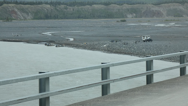
Soon we could see McCarthy off in the distance, over on the other side of the valley line right before the mountain swoop upwards. We know we were almost there as we were descending lower and lower to get to the river.

And sure enough, here we were! This is called Base Camp. We are right by the river and the footbridge to cross over into McCarthy. Many people just park here and walk across for the day. But we were going to spend the night!

We paid our $35 camping fee at the Visitor Center. There's a really nice guy in there name Mike who gave us the low down on a lot of the local information. He suggested for our camping, to locate further to the west of the parking lot where there are campsites dotted throughout by the lake shore. He suggested those were the nicest sites. It was pretty rough driving out there, but we crawled our way through and made it to a really nice site. Nose facing outward to the lake.

It was quite breezy, but it was well worth the view. All of this water in front of us in this lake is run off from the Root Glacier just up around the bend. We got settled in and started to make some supper. It was pretty late in the day and we were tired. No exploring McCarthy tonight. It was time to just relax and unwind. Especially Steve, having two hands on the wheel for the last 3 to 4 hours to get out here.
We got Nick out and about to ram around and burn off some of his energy. This was pretty rugged terrain of all rocks and dirt. He wasn't too happy not finding grass to pee on. But he made do, and we settled in for the night.

Such a handsome little Alaskan Mountain Dog... Right?

97 Miles traveled today
3,925 Miles traveled so far


Beautiful area, thanks for sharing!
ReplyDeleteThanks so much for being here and reading along with us as we travel!
DeleteAll that open space and they charge $35 for dry camping...?
ReplyDeleteWe could have parked a few miles up the road in the woods for free and walked down. But we didn't want to leave Nick alone in the woods in the RV for hours on end while we toured the town and mine. Our plans were to rent e-bikes and ride into town and then up to the mine, but it was raining. So we parked close and paid the fee. Then we could come back and forth for Nick and watch him on our Wi-Fi camera. It all worked out, and it was worth it.
Delete