Steve was looking carefully on the maps, while I was pulling up some of our camping apps to get information for our next destination. He found some campgrounds right out in the middle of the St Lawrence Seaway between New York State and Canada.
One of them is still on the United States side and a part of the New York State Park system. The rest of them are on a chain of islands that are connected by little bridges that are on the Canadian Provincial Park system. We decided to first go to the one on Barnhart Island.
As we got close to the park we were surprised by having to go down through a tunnel! It was a tunnel that goes underneath the lock for the shipping channel to allow ships to get up river past the huge dam.
Here was the other side already so we could see our way clear. Was interesting all the tiles down the sides of the tunnel are like traditional subway tiles you see in the big cities.
Here is what it looks like from up above:
Once we got past that portion of the park, we found our way down to the office. It was way down by the beach on the far western shore of the island.
The very helpful gal at the desk was able to locate three sites that would be available through the weekend. The weather was threatening thunderstorms, so they had had some cancellations. We were given a choice of three different sites, one of which she said was wooded. So we decided we would trust her and take that one. We took it for two nights and it was $38 for one night but $30 for every night after that. We don't know why. She said the site would still be available all the way through Wednesday of the next week if we wanted it. But for now we just took Friday and Saturday nights.
We didn't grab a map of the park, which we really should have. But we got back into the motorhome and went back to where we had seen a sign that said Campground Road. We figured that's where our campsite was. We turned on that road and we were met with this absolutely huge green bridge! In the middle of a campground??
After we crossed the bridge then we came across this really steep hill going down and then another incline back up again. I think it's part of a floodway area in case they ever had to release the dams.
We found our way into the campground. It was a series of about eight different loops. We went around and around looking for our site number 248. We just weren't finding any loops that went high enough in numbers. Actually, in this part of the campground all the sites were pretty close together. And they were located in a lot of wide open grassy spaces. It really wasn't what we wanted for pleasant camping.
Because we didn't have a campground map we really weren't finding where our campsite was. Finally, a maintenance crew came by in their little vehicle and we stopped and asked them where to go. They said we were in the wrong portion and to go all the way back to the office and instead go beyond the office up the shoreline and there were another two small loops of campsites up there. That is where our site was. Sounds good to us!
So we backtracked through the really steep incline and decline, and now came up from the other direction on the green bridge. I got a better photo of it this time.
We went all the way back to the office and then through the back corner of the parking lot. Ahhhhh there was one small tiny sign that says campsites with the number range of what we needed. Silly us, we should have asked when we first registered where to go or at least grabbed the map.
This was more like it! We had nice roomy sites, spaced far apart from any other sites. We could barely see one site across and down the road from us. The nice shrubbery around us blocked the view from anywhere else around our little loop. Just around the corner was a nice bathroom and shower building, and around the other corner was the waste cans and recycling can. Side note: the staff came through multiple times every day taking trash out of the small waste area. I think it helps keep down the bear and coon population.
We were all set up, level and cozy in our nice little campsite for two nights.
We could hear the water behind us of the St Lawrence Seaway through the trees. There was a little path to get back to the shoreline just a few sites down from our site. Once we were settled in, we took a little walk to see what we could see.... The St Lawrence "see"-way? Lol
The earlier drizzly morning broke free and we had puffy clouds and blue sky. The slight breezes were enjoyable and it was a great walk with temps in the low 70s.
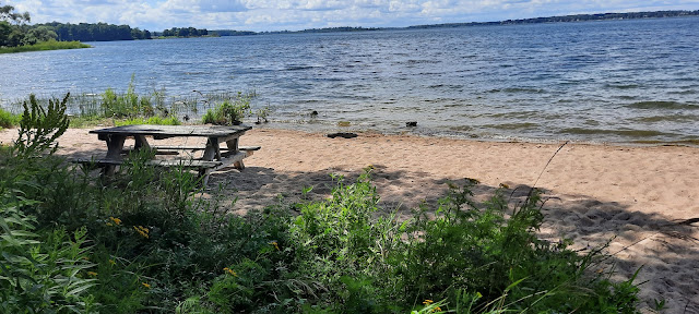
We sat down on this little picnic table in the sand. We enjoyed the view out across the Seaway and the various islands dotting the horizon.
What a great morning. It was so pleasant to just sit back and relax for a little bit and not rush rush rush. It was so quiet here there was nobody else around. This is the type of camping we like to do.
There had been rain overnight and I noticed all the little pock marks in the sand from the big raindrops. The texture was really interesting. I just enjoyed sitting at the table and taking it all in.
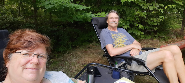
We hauled out our reclining lawn chairs and stretched out for the afternoon. I caught up some of my journal and some of my past blogs. The internet signal is pretty good here coming in on Steve's phone, which is Visible through Verizon. He has international data and calling. Because we are so close to the Canadian border, I removed the SIM card from my phone from about 20 miles back down the road. That way I'm sure my phone does not hop over to Canadian towers. The rates for roaming internationally by accident are pretty high with the plan I have from a little local carrier back in Wisconsin.
(That happened to us once when we were traveling near the Mexican border, my cell phone jumped to Mexico and we had a huge $450 bill! But we had called the cell phone carrier and explained we never did cross into Mexico and they removed the charge. But they explained you better remove your sim card at the same time until you get far enough away)
We spent a couple days just relaxing and taking it easy. We went back down to the shoreline with our binoculars and watched some of the boats and cabins over on the Canadian shore. We watched birds and enjoyed the sunshine. We had too many past days of rain that we had been feeling waterlogged.
There was so much sunshine, we actually rolled out our awning for the first time in about a week. We also decided, after looking at the weather, to stay one more day. Sunday's weather was supposed to get very hot and humid into the high 80s. So we figured it was best to walk over to the office and pay for one more day.
(But it never did, and we enjoyed a beautiful Day on Sunday)
Now it's Monday morning. It's going to be a travel day. We are going to first go back through the deep dip down and up incline decline and then over the green bridge to get to the dump station which is located on the other end of the campground. Then we will come back through the green bridge and up and down the deep dip and turn right and go down through the tunnel under the lock.
Maybe I will have a chance to video it.
Then we will head into town and top off our diesel fuel tank as well as our propane tank. Best to do this over on the US side before we head over to the bridge at Cornwall and cross into Canada.
We used up all of our vegetables and fruits and eggs over the last few days so we have everything set to cross the border.
We might check out the chain of the islands further up the St Lawrence Seaway that are accessed from the Canadian side. After that we are hoping to loop up around through Algonquin Provincial Park, through Sudbury, then through the Sault Sainte Marie locks down into the Upper Peninsula of Michigan. From there it's back into Wisconsin which is just a short hop skip and jump for us.
46 Miles traveled today
1,853 miles overall


I want to travel with you and Steve. You find the best camping spots. Love the picture of you at the picnic table.
ReplyDelete